Rural Geographic Information Systems

  • Home
  • Croft Mapping
  • Habitat Mapping
  • East Sutherland Participative GIS
  • Dunnet & Canisbay PPGIS
  • GIS Training
  • MSc in GIS
  • Photography
  • Iain Turnbull
  • Contact Us

Welcome Back

12/17/2013

0 Comments

 
Picture
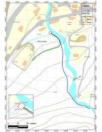
Micro Hydro Scheme Map
It has been a long time since I updated the website or the blog, mainly due to 2013 being an incredibly busy time in my life with my main job with the National Trust for Scotland and my personal life, coaching hockey, cycling, etc.  I have been doing a few pieces of work for Rural GIS though: ongoing planning and tendering for the Plock of Kyle Access project, which is about to kick off in the New Year; a small job digitising data for an amphibian and reptile survey of a community woodland in Broadford; mapping a croft micro hydro scheme; doing some mapping and photo-montage work for a proposed mussel farm; and familiarising myself more seriously with Quantum GIS with the aim of developing a short introductory course for small-scale consultancy businesses and land managers/owners.  I am also hoping to develop closer links with the West Highland College to deliver GIS training there.

Anyway, hopefully I will keep the blog moving a bit more in 2014, so meanwhile have a merry Christmas and a Happy New Year when it comes.

0 Comments

Happy 2013

1/8/2013

0 Comments

 
Happy New Year to everyone.  Rural GIS is looking forward to developing its business on from a very successful 2012 with croft mapping being the most likely prospect for new work.  That being said we are keen to develop our range of services so if any of you are needing mapping services or more complex GIS support please get in touch.  We also offer a range of environmental management and conservation advisory services, including expertise in management planning so get in touch.
0 Comments

Merry Christmas and Happy New Year from Rural GIS

12/20/2012

0 Comments

 
Picture
Merry Christmas and a Happy New Year to all our valued customers.
Rural GIS will be closed for the festive season from 22nd December to 6th January inclusive.  If you have any queries or work needing done please send an email to Iain Turnbull at iain.turnbull@ruralgis.com or use the contact form on the Contact Us page of this website.  We will get back to you as soon as possible after the New Year.
In 2012 we hope to have regular updates to our website and are looking forward to an increase in crofting related work following the new Croft Register going live at the beginning of December.  However, we are also keen to take on other GIS and land management consultancy work, so give us a call or drop us an email if you require our services.

0 Comments

Chartered Geographer

10/28/2012

1 Comment

 
I was very pleased to receive an email from the Royal Geographical Society yesterday informing me that my application to be a Chartered Geographer had been approved by the RGS Council.  This is recognition of my gradual transition over the years from an ecologist to much more of a geographer.  I guess this all started when I moved to Skye in 1990 to begin working as a Research Assistant for Skye Forum and Habitat Scotland on a project to develop a Resource Data Atlas for Skye.  Following 4 plus years in Edinburgh as a Management Planner for NTS I moved to Balmacara as Property Manager and that is when my transition to geographer really began.  GIS has become a major part of my working life, initially trying to gather together the vast array of information about Balmacara to assist in managing the estate, and then in 2007 when I enrolled in a part-time distance learning MSc in GIS at Leeds, Southampton & Penn State universities.  This all concluded in 2010 when I finished the course and since then I have been busy establishing my Rural GIS business.
A major responsibility of being a Chartered Geographer is to promote geography in all its guises.  I feel thhat having spent 20 plus years working in the field of conservaton and land management I have gained experience of an enormous range of interacting and related processes and functions that represent the countryside, communities and environment of the Highlands & Islands.  I am now very focused upon promoting my business but am also keen to work with school groups to develp the undertsanding of the complex ineractions between the environment and people.  I hope to spend soe time workng with pupils at Plockton High School to promote the use of GIS in the school in their studies of Geography and other subject as well.  Maybe there will be more on this later
1 Comment

Mobile Mapping Capability for Rural GIS

10/15/2012

0 Comments

 
This last few weeks has been a busy time for Rural GIS and following a successful year we have invested in the business by buying an Ashtech Mobile Mapper 10 device with PocketGIS mobile mapping software.  This new device will allow efficient and accurate recording of field data and transfer of data to and from our main GIS systems.  Possible uses of equipment might include:
  • biological survey, e.g. bird or plant surveys;
  • mapping boundaries, e.g. croft or title surveys;
  • mapping access routes, e.g. footpaths, roads, etc;
  • mapping services and other facilities;
  • visualising map data in the field and for PPGIS activities. 


The device has an accurate GPS received and is capable of 1-3 m accuracy in the field, depending on the location, and with post-processing back in the office this can be improved to less than 1 m accuracy.  One very obvious application of this technology might be in recording the boundaries of crofts and common grazings, with the advent of the new map-based Register of Crofts in November.  more to follow on this in coming weeks...
0 Comments

Plock of Kyle Access Project

10/15/2012

0 Comments

 
Picture
For the past 6 months or so Rural GIS has been wroking with members of the Hamilton Park Trustees and Kyle Development Group, along with other specialist consultants, to develop a Stage 2 application to the Lottery's Community Spaces programme.  The application is for the improvement of access and increasing the visibility of the Plock of Kyle to residents and visitors.  The Plock is a small area of community owned land that was giftyed to the residents of Kyle in the 1940s for recreational use.  For a long period of time the area had a 9-hole golf course and various paths.  however, over the last 20 years or so the area has declined in use and the gold course has been lost as natural vegetation has encroached.  There is a Core Path running from the main flagpole viewpoint to the lower car park and back but apart from that the paths are now mainly informal routes and all are subject to dense growth of rank vegetation.  The project aims to create a new route from the village to the viewpoint, a new all-abilities circular path and a new route from the old Skye Bridge Toll Booth Offices up to the lower car park.  There will be significant control of vegetation along all the access routes and roadways to open up the area and encourage greater use by the public.  The road access routes will also be improved and new signage and waymarking will raise the profile of this valuable recreational space.

The application was submitted on 12th October and if successful work will commence in the spring of 2013 and will be carried out over a two year period.  Hopefully this will lead to a greater appreciation of this community space and lead to more interest from within the village generally.
0 Comments

Spectacular Uist

6/25/2012

0 Comments

 
View of South Uist from the dunes at  Lionacleit
South Uist hills from the dunes at Lionacleit
Just back from a spectacular trip to Uist and Benbecula last week.  The weather was brilliant as you can see and no midges.  Lots of excellent birding with 82 species seen in four days including highlights like a full breeding plumage male ruff, a male red-necked phalarope, great views of male hen harrier and short eared owl and on the last day a whole family of corncrake including three chicks.

The views to St Kilda were excellent and the sandy beaches are truly spectacular in the sunlight.  We even had an amazing sunset moment at Lionacleit on the first night, sadly I didn't have my camera with me to capture it, but the hills of South Uist were illuminated by the setting sub against a dark purple cloudy sky and a bright rainbow all at once.  Amazing!

0 Comments

Plock of Kyle Access Audit

2/17/2012

0 Comments

 
View of the Skye Bridge from the Plock Viewpoint
Skye Bridge from Plock Viewpoint
Rural GIS has been engaged by the Kyle Development Group and the Scottish Community Foundation to undertake an Access Audit for the Plock of Kyle.  The Plock is located at the western end of the Lochalsh peninsula and is where the Skye Bridge leaves the mainland.  The site was gifted by Sir Daniel Hamilton for recreational purposes to Trustees on behalf of the community of Kyle of Lochalsh.

The audit will be carried out over the next few weeks and will be used to facilitate upcoming community consultation over possible improvements to the access infrastructure of the Plock.  The Trustees have applied to the Lottery Community Spaces Fund for a grant to help develop a project to improve the exisitng footpath newtwork on the Plock and to investigate options for establishment of new footpath access routes to the Plock from the vicinity of the old Skye Bridge Toll Booth offices and from the centre of the village.  If the application for funding is successful they will have 6 months to develop the project, including the community consultation, after which they will hopefully be awarded a further grant to implement the agreed outputs.

0 Comments

Phase I Habitat Mapping

12/15/2011

0 Comments

 
I have just completed a contract for ABI Wildlife Consultancy (operated by a friend and ex-colleague - Abbie Paterson) to digitise some phase 1 habitat survey maps of three campuses at Edinburgh Napier University.  One issue I came across was how to set up standard thematic displays of the habitat types according to the JNCC colour scheme for Phase I survey.  I eventually found an ArcGIS style file on the JNCC website, but I wonder if anyone else has come across this issue and has either found one for other software or has developed one themselves?
Picture
Example of Phase I Habitat Map
0 Comments

PPGIS Exercise in Rogart, Sutherland

12/15/2011

0 Comments

 
In September Rural GIS was contracted by the Scottish Community Foundation to assist in a community consultation exercise to explore ideas for utilising a community fund being built up from the Gordonbush Wind Farm development.  More detail is provided on the relevant page on the main website.  The PPGIS approach utilised was very simple and was based on a similar exercise undertaken by Iain Turnbull for the Kyle Development Group as part of their Kyle Conversation in the spring of 2011.  Basically individuals were encouraged to look at GIS maps of their locality on a big screen and to mark on ideas and issues that they considered to be of interest or concern.  Attributes were attached to the point data which described the issue/opportunity and broadly categorised it for later analysis.  While very simple from a GIS perspective I have found that this approach helps people to visualise how things might relate to each other and some ideas feed off others, etc.  I hope to build on this technique with some further research and reading on the subject of PPGIS.  If anyone reads this and has suggestions or tools that could beused for this please send me an email at iain.turnbull@ruralgis.com and I will get back to you.
0 Comments
<<Previous

    Iain Turnbull

    Director of Rural GIS

    Categories

    All

    RSS Feed

Powered by Create your own unique website with customizable templates.