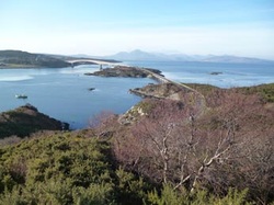
Skye Bridge from Plock Viewpoint
Rural GIS has been engaged by the Kyle Development Group and the Scottish Community Foundation to undertake an Access Audit for the Plock of Kyle. The Plock is located at the western end of the Lochalsh peninsula and is where the Skye Bridge leaves the mainland. The site was gifted by Sir Daniel Hamilton for recreational purposes to Trustees on behalf of the community of Kyle of Lochalsh.
The audit will be carried out over the next few weeks and will be used to facilitate upcoming community consultation over possible improvements to the access infrastructure of the Plock. The Trustees have applied to the Lottery Community Spaces Fund for a grant to help develop a project to improve the exisitng footpath newtwork on the Plock and to investigate options for establishment of new footpath access routes to the Plock from the vicinity of the old Skye Bridge Toll Booth offices and from the centre of the village. If the application for funding is successful they will have 6 months to develop the project, including the community consultation, after which they will hopefully be awarded a further grant to implement the agreed outputs.
The audit will be carried out over the next few weeks and will be used to facilitate upcoming community consultation over possible improvements to the access infrastructure of the Plock. The Trustees have applied to the Lottery Community Spaces Fund for a grant to help develop a project to improve the exisitng footpath newtwork on the Plock and to investigate options for establishment of new footpath access routes to the Plock from the vicinity of the old Skye Bridge Toll Booth offices and from the centre of the village. If the application for funding is successful they will have 6 months to develop the project, including the community consultation, after which they will hopefully be awarded a further grant to implement the agreed outputs.
 RSS Feed
